Regional Parks and Trails System Plan
Table of Contents
Open to the public
Regional parks - table with key for map
Park reserves - table with key for map
Special features - table with key for map
Map - regional parks, park reserves, special features
Regional trails - table with key for map
Map - Regional trails
Map - Regional Parks and Trails System facilities
Not open to the public
Planned regional parks and park reserves - table with key for map
Planned regional trails - table with key for the map
Map - Planned regional parks and trails
Boundary adjustments and regional park and special feature search areas
Long-range plan boundary adjustments - table with key for map
Regional park search areas - table with key for map
Special feature search area - table with key for map
Map - Boundary adjustments, regional park, and special feature search areas
Search corridors
Regional trail search corridors - table with key for the map
Map - Regional trail search corridors
System Plan Summary and Estimates
2050 Regional Parks and Trails System Plan Summary
Estimated cost to implement the System Plan
Other
Map - Unbuilt portions of the regional parks and trails system
Regional Parks and Trails System Five-Year Capital Improvement Plan, 2025-2029 (in millions)
There are four implementation status categories described in the system plan. Together, these categories make up the 2050 Regional Parks and Trails System:
- Open to the Public Regional Parks and Trails System units
- Planned Regional Parks and Trails System units that are not yet open to the public
- Regional Parks and Trails System boundary adjustments
- Regional Park search areas and Regional Trail search corridors
Open to the Public Regional Parks and Trails System facilities
The Regional Parks and Trails System, as of 2025, includes 46 regional parks, 12 park reserves, 56 regional trails, and 8 special features that are open for public use. The system includes 65,339 acres of land in a protected status.
Open to the Public Regional Parks, Park Reserves, and Special Features
As of 2025, there are 66 regional parks, park reserves, and special features developed and open to the public. These units are listed in Tables 2.1, 2.2, and 2.3 and shown in Figures 2.1 and 2.3.
| Regional Park Implementing Agency | Regional Park | Map # |
|---|---|---|
| Anoka County | Riverfront Regional Park | P1 |
| Anoka County | Bunker Hills Regional Park | P2 |
| Anoka County | Coon Rapids Dam Regional Park | P3 |
| Anoka County | Lake George Regional Park | P4 |
| Anoka County | Martin-Island-Linwood Lakes Regional Park | P5 |
| Anoka County | Mississippi West Regional Park | P6 |
| Anoka County | Rum River Central Regional Park | P7 |
| Anoka County | Coon Lake Regional Park | P8 |
| Carver County | Baylor Regional Park | P9 |
| Carver County | Lake Minnewashta Regional Park | P10 |
| Carver County | Lake Waconia Regional Park | P11 |
| Dakota County | Lake Byllesby Regional Park | P12 |
| Dakota County | Lebanon Hills Regional Park | P13 |
| Dakota County | Whitetail Woods Regional Park | P14 |
| Minneapolis Park & Recreation Board | Above the Falls Regional Park | P15 |
| Minneapolis Park & Recreation Board | Central Mississippi Riverfront Regional Park | P16 |
| Minneapolis Park & Recreation Board | Minneapolis Chain of Lakes Regional Park | P17 |
| Minneapolis Park & Recreation Board | Minnehaha Regional Park | P18 |
| Minneapolis Park and Recreation Board/Saint Paul | Mississippi Gorge Regional Park | P19 |
| Minneapolis Park & Recreation Board | Nokomis-Hiawatha Regional Park | P20 |
| Minneapolis Park & Recreation Board/Three Rivers Park District | North Mississippi Regional Park | P21 |
| Minneapolis Park & Recreation Board | Theodore Wirth Regional Park | P22 |
| Ramsey County | Bald Eagle-Otter Lake Regional Park | P23 |
| Ramsey County/Saint Paul | Battle Creek & Indian Mounds Regional Park | P24 |
| Ramsey County | Long Lake Regional Park | P25 |
| Ramsey County/Saint Paul | Phalen-Keller Regional Park | P26 |
| Ramsey County | Tony Schmidt Regional Park | P27 |
| Ramsey County | Vadnais-Snail Lake Regional Park | P28 |
| Saint Paul/Ramsey County | Battle Creek & Indian Mounds Regional Park | P24 |
| Saint Paul | Como Regional Park | P29 |
| Saint Paul | Hidden Falls-Crosby Farm Regional Park | P30 |
| Saint Paul | Lilydale-Harriet Island & Cherokee Heights Regional Park | P31 |
| Saint Paul/Minneapolis Park & Recreation Board | Mississippi Gorge Regional Park | P19 |
| Saint Paul/Ramsey County | Phalen-Keller Regional Park | P26 |
| Scott County | Cedar Lake Farm Regional Park | P32 |
| Scott County/Three Rivers Park District | Cleary Lake Regional Park | P33 |
| Scott County | Doyle-Kennefick Regional Park | P34 |
| Scott County | Spring Lake Regional Park | P35 |
| Three Rivers Park District | Bryant Lake Regional Park | P36 |
| Three Rivers Park District/Scott County | Cleary Lake Regional Park | P33 |
| Three Rivers Park District | Clifton E. French Regional Park | P37 |
| Three Rivers Park District | Eagle Lake Regional Park | P38 |
| Three Rivers Park District | Fish Lake Regional Park | P39 |
| Three Rivers Park District | Lake Minnetonka Islands Regional Park | P40 |
| Three Rivers Park District | Lake Minnetonka Regional Park | P41 |
| Three Rivers Park District | Lake Sarah Regional Park | P42 |
| Three Rivers Park District | Coon Rapids Dam Regional Park/Mississippi Gateway Regional Park | P43 |
| Three Rivers Park District/Minneapolis Park & Recreation Board | North Mississippi Regional Park | P21 |
| Washington County | Cottage Grove Ravine Regional Park | P44 |
| Washington County | Pine Point Regional Park | P45 |
| Washington County | St. Croix Bluffs Regional Park | P46 |
| Regional Park Implementing Agency | Park Reserves | Map # |
|---|---|---|
| Anoka County | Rice Creek Chain of Lakes Park Reserve | PR1 |
| Bloomington/Three Rivers Park District | Hyland-Bush-Anderson Lakes Park Reserve | PR2 |
| Dakota County | Miesville Ravine Park Reserve | PR3 |
| Dakota County | Spring Lake Park Reserve | PR4 |
| Scott County/Three Rivers Park District | Murphy-Hanrehan Park Reserve | PR5 |
| Three Rivers Park District | Baker Park Reserve | PR6 |
| Three Rivers Park District | Carver Park Reserve | PR7 |
| Three Rivers Park District | Crow-Hassan Park Reserve | PR8 |
| Three Rivers Park District | Elm Creek Park Reserve | PR9 |
| Three Rivers Park District/Bloomington | Hyland-Bush-Anderson Lakes Park Reserve | PR2 |
| Three Rivers Park District | Lake Rebecca Park Reserve | PR10 |
| Three Rivers Park District/Scott County | Murphy-Hanrehan Park Reserve | PR5 |
| Washington County | Big Marine Park Reserve | PR11 |
| Washington County | Lake Elmo Park Reserve | PR12 |
| Regional Park Implementing Agency | Special Recreation Feature | Map # |
|---|---|---|
| Saint Paul | Como Park Zoo | SF1 |
| Saint Paul | Marjorie McNeely Conservatory | SF2 |
| Three Rivers Park District | Gale Woods Farm | SF3 |
| Three Rivers Park District | Kingswood | SF4 |
| Three Rivers Park District | Noerenberg Gardens | SF5 |
| Three Rivers Park District | Silverwood | SF6 |
| Three Rivers Park District | The Landing | SF7 |
| Washington County | Square Lake | SF8 |

Open to the Public Regional Trails
As of 2025, there are 56 regional trail corridors with a total of 487 miles open to the public, listed in Table 2.4 and Figures 2.2 and 2.3. Many trails are constructed in phases, with some as part of roadway improvement projects or local developments. Therefore, although a trail is listed as being open, some portions of the trail corridor may be developed in the future and are not yet open to the public.
| Regional Park Implementing Agency | Regional Trails | Map # |
|---|---|---|
| Anoka County | Bunker Hills-Chain of Lakes Regional Trail | T1 |
| Anoka County | Central Anoka Regional Trail | T2 |
| Anoka County | Chain of Lakes-Otter Lake Regional Trail | T3 |
| Anoka County | Coon Creek Regional Trail | T4 |
| Anoka County | East Anoka County Regional Trail | T5 |
| Anoka County/Dakota County | Mississippi River Regional Trail/Mississippi River Greenway Regional Trail | T6 |
| Anoka County/Ramsey County | Rice Creek North Regional Trail | T7 |
| Anoka County/Ramsey County | Rice Creek West Regional Trail | T8 |
| Anoka County | Rum River Regional Trail | T9 |
| Anoka County | Sugar Hills Regional Trail | T10 |
| Bloomington/Three Rivers Park District | Canadian Pacific Rail Regional Trail – Segment A | T11 |
| Bloomington/Three Rivers Park District/Minneapolis Park & Rec Board | Nokomis-Minnesota River Regional Trail | T12 |
| Carver County/Three Rivers Park District | Dakota Rail Regional Trail | T13 |
| Carver County | Highway 5 Regional Trail | T14 |
| Carver County/Three Rivers Park District | Lake Minnetonka Regional Trail | T15 |
| Carver County/Three Rivers Park District | Minnesota River Bluffs Regional Trail | T16 |
| Carver County | Southwest Regional Trail | T17 |
| Dakota County | Big Rivers Regional Trail | T18 |
| Dakota County | Lebanon Hills Greenway Regional Trail | T19 |
| Dakota County | Minnesota River Greenway Regional Trail | T20 |
| Dakota County/Anoka County | Mississippi River Greenway Regional Trail/ Mississippi River Regional Trail | T6 |
| Dakota County | North Creek Greenway Regional Trail | T21 |
| Dakota County | River to River Greenway Regional Trail | T22 |
| Minneapolis Park & Recreation Board/Three Rivers Park District | Cedar Lake Regional Trail | T23 |
| Minneapolis Park & Recreation Board | Columbia Parkway Regional Trail | T24 |
| Minneapolis Park & Recreation Board | Kenilworth Regional Trail | T25 |
| Minneapolis Park & Recreation Board/Three Rivers Park District | Luce Line Regional Trail | T26 |
| Minneapolis Park & Recreation Board | Minnehaha Parkway Regional Trail | T27 |
| Minneapolis Park & Rec Board/ Bloomington/Three Rivers Park District | Nokomis-Minnesota River Regional Trail | T12 |
| Minneapolis Park & Recreation Board/Three Rivers Park District | Northeast Diagonal Regional Trail | T28 |
| Minneapolis Park & Recreation Board | Ridgway Parkway Regional Trail | T29 |
| Minneapolis Park and Recreation Board/Three Rivers Park District | Shingle Creek Regional Trail | T30 |
| Minneapolis Park & Recreation Board | St. Anthony Parkway Regional Trail | T31 |
| Minneapolis Park & Recreation Board | Victory Memorial Parkway Regional Trail | T32 |
| Ramsey County | Birch Lake Regional Trail | T33 |
| Ramsey County/Saint Paul | Bruce Vento Regional Trail | T34 |
| Ramsey County | Highway 96 Regional Trail | T35 |
| Ramsey County/Washington County | Lake Links Regional Trail | T36 |
| Ramsey County/Anoka County | Rice Creek North Regional Trail | T7 |
| Ramsey County/Anoka County | Rice Creek West Regional Trail | T8 |
| Ramsey County/Saint Paul | Trout Brook Regional Trail | T37 |
| Saint Paul/Ramsey County | Bruce Vento Regional Trail | T34 |
| Saint Paul | Grand Round North Regional Trail | T38 |
| Saint Paul | Robert Piram Regional Trail | T39 |
| Saint Paul | Samuel Morgan Regional Trail | T40 |
| Saint Paul/Ramsey County | Trout Brook Regional Trail | T37 |
| Scott County | Big Woods Regional Trail (formerly Scott West Regional Trail) | T41 |
| Scott County | Spring Lake Regional Trail | T42 |
| Three Rivers Park District | Baker-Carver Regional Trail | T43 |
| Three Rivers Park District | Bassett Creek Regional Trail | T44 |
| Three Rivers Park District/Minneapolis Park and Recreation Board | Cedar Lake Regional Trail | T23 |
| Three Rivers Park District/Bloomington | Canadian Pacific Rail Regional Trail - Segment A | T11 |
| Three Rivers Park District | Crow River Regional Trail | T45 |
| Three Rivers Park District | Crystal Lake Regional Trail | T46 |
| Three Rivers Park District/Carver County | Dakota Rail Regional Trail | T13 |
| Three Rivers Park District | Lake Independence Regional Trail | T47 |
| Three Rivers Park District/Carver County | Lake Minnetonka Regional Trail | T15 |
| Three Rivers Park District/Minneapolis Park and Recreation Board | Luce Line Regional Trail | T26 |
| Three Rivers Park District | Medicine Lake Regional Trail | T48 |
| Three Rivers Park District/Carver County | Minnesota River Bluffs Regional Trail | T16 |
| Three Rivers Park District | Nine Mile Creek Regional Trail | T49 |
| Three Rivers Park District/Bloomington/Minneapolis Park & Recreation Board | Nokomis-Minnesota River Regional Trail | T12 |
| Three Rivers Park District | North Cedar Lake Regional Trail | T50 |
| Three Rivers Park District/Minneapolis Park and Recreation Board | Northeast Diagonal Regional Trail | T28 |
| Three Rivers Park District | Rush Creek Regional Trail | T51 |
| Three Rivers Park District/Minneapolis Park and Recreation Board | Shingle Creek Regional Trail | T30 |
| Three Rivers Park District | Twin Lakes Regional Trail | T52 |
| Three Rivers Park District | West Mississippi River Regional Trail | T53 |
| Washington County | Central Greenway Regional Trail – South and Central Lake Elmo Segments | T54 |
| Washington County | Hardwood Creek Regional Trail | T55 |
| Washington County/Ramsey County | Lake Links Regional Trail | T36 |
| Washington County | Point Douglas Regional Trail | T56 |


Planned Regional Parks and Trails System facilities
In addition to the facilities that are open to the public, there is one regional park and one park reserve that have Met Council-approved long-range plans but have not yet been developed. These facilities are listed in Tables 2.5 and 2.6 and shown in Figure 2.4.
| Regional Park Implementing Agency | Regional Park | Map # |
|---|---|---|
| Washington County | Grey Cloud Island Regional Park | PP1 |
| Regional Park Implementing Agency | Park Reserve | Map # |
| Scott County | Blakeley Bluffs Park Reserve | PPR1 |
16 regional trails have Met Council-approved long-range plans but are not yet developed or open to the public, as listed in Table 2.6 and shown in Figure 2.4.
| Regional Park Implementing Agency | Regional Trail | Trail Mileage | Map # |
|---|---|---|---|
| Dakota County | Lake Byllesby Greenway Regional Trail | 3 | PT1 |
| Dakota County | Lake Marion Greenway Regional Trail | 20 | PT2 |
| Dakota County | Rosemount Greenway Regional Trail | 13 | PT3 |
| Dakota County | Vermillion Highlands Greenway Regional Trail | 13 | PT4 |
| Dakota County | Vermillion River Greenway Regional Trail | 5.35 | PT5 |
| Dakota County | Veterans Memorial Greenway Regional Trail | 5 | PT6 |
| Minneapolis Park and Recreation Board | Grand Rounds Missing Link Regional Trail | 5 | PT7 |
| Saint Paul | Point Douglas Regional Trail (formerly Point Douglas (Bruce Vento-Washington Co)) | 4 | PT8 |
| Saint Paul | Summit Avenue Regional Trail | 5.4 | PT9 |
| Scott County | Merriam Junction Regional Trail (formerly Minnesota River Bluffs Extension and Scott County Connection Regional Trail including the Louisville-Merriam Junction Regional Trail) | 7.9 | PT10 |
| Scott County | Shallow Waters Regional Trail (formerly a part of the Southern Scott Trail Search Corridor) | 17 | PT11 |
| Three Rivers Park District | Bryant Lake Regional Trail (formerly Eagle-Bryant Lake Trail Search Corridor) | 4.7 | PT12 |
| Three Rivers Park District | Diamond Lake Regional Trail (formerly Diamond Lake Trail Search Corridor) | 28.1 | PT13 |
| Three Rivers Park District | Eagle Lake Regional Trail (formerly Eagle-Bryant Lake Trail Search Corridor) | 12.3 | PT14 |
| Washington County | Middle St. Croix Valley Regional Trail (formerly Middle St. Croix Valley Search Corridor) | 14 | PT15 |
| Washington County | St. Croix Valley Regional Trail | 17.4 | PT16 |

Boundary adjustments
The 2050 Regional Parks and Trails Policy Area recommends a long-range plan boundary adjustment for Carver County’s Baylor Regional Park to protect high-quality natural features and provide recreational opportunities.
The proposed boundary adjustment is included in the 2050 System Plan and described in Table 2.7 and Figure 2.5.
| Regional Park Implementing Agency | Regional Parks System Unit | Estimated Acreage | Description | Map # |
|---|---|---|---|---|
| Carver County | Baylor Regional Park | 100 | Acquire approximately 100 acres of land adjacent to Eagle Lake, including lakeshore. | BA1 |
Regional park search areas
Six regional park search areas, totaling approximately 3,586 acres, are described in Table 2.8. Figure 2.5 shows a map of the boundary adjustments, regional park search areas, and special feature bridging facility search areas. Regardless of estimated acreages, regional park search areas are depicted with the same size symbols in Figure 2.5. Regional park search areas are meant to denote general areas and do not specify exact locations at this scale. Future long-range planning work by regional park implementing agencies will determine specific boundaries for these regional park search areas.
| Regional Park Implementing Agency | Regional Park Search Area | Estimated Acreage | Description | Map # |
|---|---|---|---|---|
| Anoka County | Rum River Regional Park Search Area | Additional acres 86 | Three parks connected by the Rum River, a Wild and Scenic River. | PSA1 |
| Anoka County | Sugar Hills Regional Park Search Area (formerly Northwest Anoka County) | 2,500 | Very high-quality natural resource area unique in Anoka County. | PSA2 |
| Carver County | Miller Lake Regional Park Search Area | 200 | Very attractive lake resource and appropriate setting for a regional park. | PSA3 |
| Carver County | Minnesota Bluffs and Ravines Regional Park Search Area | 500 | Large areas of regionally significant natural resources, excellent recreation potential. | PSA4 |
| Three Rivers Park District | Minnetonka/Minnehaha Creek Regional Park Search Area | 100 | A linear, creek-based regional park/greenway along the Minnehaha Creek corridor within Hennepin County. | PSA5 |
| Three Rivers Park District | Rogers-Corcoran Regional Park | 200 | Rich in wetlands, rolling hills and scenic vistas. | PSA6 |
Special feature search area
One special feature bridging facility search area, spanning 11 cities, is described in Table 2.9. Figure 2.5 shows a map of the boundary adjustments, regional park search areas, and special feature bridging facility search areas.
| Regional Park Implementing Agency | Special Feature Search Area | Description | Map # |
|---|---|---|---|
| Three Rivers Park District | First-Ring Cities Bridging Facility Search Area | A set of several unique proposed bridging facilities spread across the cities. | SPF1 |

Regional trail search corridors
There are 48 proposed regional trails without Met Council-approved long-range plans that identify the trail alignments. Many of these trails have been considered part of the Regional Parks and Trails System for several years and were mapped in previous Regional Parks Policy Plans as proposed trails showing a tentative alignment. Since alignments for these trails have not yet been approved by the Met Council as part of a long-range plan and are therefore not eligible for Regional Parks and Trails System funding for acquisition and development, they are being shown as regional trail search corridors. The regional trail search corridors are listed in Table 2.10 and shown in Figure 2.6.
| Regional Park Implementing Agency | Regional Trail Search Corridor | Est. Miles | Map # |
|---|---|---|---|
| Anoka County | North Anoka County | 30 | TSC1 |
| Bloomington/Three Rivers Park District | Progressive Rail | 9 | TSC2 |
| Carver County | County Road 10 | 19 | TSC3 |
| Carver County | County Road 61 | 1 | TSC4 |
| Carver County | Highway 11 | 4 | TSC5 |
| Carver County | Highway 41 | 3 | TSC6 |
| Carver County/Three Rivers Park District | Highway 101 | 4.8 | TSC7 |
| Carver County | Lake Waconia | 6 | TSC8 |
| Carver County | Lake Waconia-Carver | 17 | TSC9 |
| Carver County | Minnesota River Bluffs LRT Extension | 6 | TSC10 |
| Carver County | Twin Cities & Western | 25 | TSC11 |
| Carver County | Western Carver County | 17 | TSC12 |
| Dakota County | Chub Creek Greenway | 20 | TSC13 |
| Dakota County | Lebanon Hills-Lake Marion Greenway | 7 | TSC14 |
| Dakota County | Lebanon Hills-Minnesota River Greenway (formerly Lebanon Hills-Big Rivers Greenway) | 7 | TSC15 |
| Dakota County | Vermillion River Greenway | 12.2 | TSC16 |
| Minneapolis Park & Recreation Board | Midtown Greenway | 6 | TSC17 |
| Ramsey County/Washington County | Afton Bluffs | 3 | TSC18 |
| Ramsey County/Saint Paul | Bruce Vento | 0.5 | TSC19 |
| Ramsey County/Saint Paul | Lexington Avenue/Parkway | 9 | TSC20 |
| Ramsey County | St. Anthony RR Spur | 10 | TSC21 |
| Ramsey County | Trout Brook Extension | 4 | TSC22 |
| Saint Paul | Grand Round - Lake Elmo Park Reserve | 6.8 | TSC23 |
| Saint Paul | Hidden Falls Regional Park to Samuel Morgan Regional Trail/ "Ford Spur" | 4.7 | TSC24 |
| Saint Paul/Ramsey County | Lexington Avenue/Parkway | 6 | TSC20 |
| Saint Paul | Mississippi Gorge Regional Park (Saint Paul) to Samuel Morgan Regional Trail/Midtown Greenway Extension | 5.7 | TSC25 |
| Scott County | Big Rivers Extension | 5 | TSC26 |
| Scott County | Cedar Lake Farm to New Prague | 6 | TSC27 |
| Scott County | Elko New Market-Blakeley-Doyle Kennefick | 32 | TSC28 |
| Scott County | Elko New Market-Doyle Kennefick | 5 | TSC29 |
| Scott County | Lake Marion to Big Woods | 6 | TSC30 |
| Scott County | Prior Lake Outlet | 6 | TSC31 |
| Scott County | Southern Scott | 18 | TSC32 |
| Three Rivers Park District | Bryant Lake (formerly Eagle-Bryant Lake Trail Search Corridor) | 10 | TSC33 |
| Three Rivers Park District | Canadian Pacific Rail - Segments B – D | 15.38 | TSC34 |
| Three Rivers Park District | Dakota Rail Extension (terminus refinement) | 3.6 | TSC35 |
| Three Rivers Park District | Eagle Lake (formerly Eagle-Bryant Lake Trail Search Corridor) | 5.2 | TSC36 |
| Three Rivers Park District | Grey’s Bay (formerly part of North-South 1; 9.5-mile extension) | 10.5 | TSC37 |
| Three Rivers Park District | Lake Independence | 2.6 | TSC38 |
| Three Rivers Park District | Lake Sarah (4-mile extension) | 18 | TSC39 |
| Three Rivers Park District | Mid-Lake (formerly part of Lake Independence Extension) | 4 | TSC40 |
| Three Rivers Park District/Bloomington | Progressive Rail | 10 | TSC2 |
| Three Rivers Park District/Carver County | Purgatory Creek (Formerly Highway 101; 6-mile extension) | 14 | TSC7 |
| Three Rivers Park District | Silverwood Connector | 2 | TSC41 |
| Three Rivers Park District | Weaver Lake | 23 | TSC42 |
| Washington County/Ramsey County | Afton Bluffs | 10 | TSC18 |
| Washington County | Central Greenway Regional Trail – North Segment (6.8-mile extension) | 18.5 | TSC43 |
| Washington County | Glacial Hills | 12 | TSC44 |
| Washington County | Lake Elmo Park Reserve to Phalen-Keller Regional Park | 7.6 | TSC45 |
| Washington County | Mississippi River | 17 | TSC46 |
| Washington County | Pine Point Regional Park to Square Lake Special Recreation Feature | 4.3 | TSC47 |
| Washington County | Prairie View | 9 | TSC48 |

2050 Regional Parks and Trails System Plan Summary
As Figure 2.7 illustrates, the updated 2050 System Plan includes:
- Regional Parks System facilities open to the public (2025)
- 46 regional parks
- 12 park reserves
- 8 special features
- 56 regional trails
- Planned Regional Parks System units that are not yet open to the public
- 1 regional park
- 1 park reserve
- 16 regional trails
- Regional Parks System boundary adjustments
- 1 regional park
- Regional park search areas
- 6 regional park search areas
- Special recreation feature search area
- 1 location siting multiple unique bridging facilities
- Regional trail search corridors
- 48 regional trail search corridors
The total park acreage and trail mileage for each implementation phase is listed below:
- Open to the Public
- Regional parks, park reserves, and special features: over 60,000 acres
- Regional trails: 487 miles
- Planned
- Regional parks, park reserves, and special features: 8,170 acres
- Regional trails (includes planned segments that are part of trails open to the public): 331.9 miles
- Search
- Regional parks, park reserves, and special features: 3,586 acres
- Regional trails: 518 miles
System-level changes
The 2025 system-level changes reflect implementing agency proposed modifications to existing units within the Regional Parks and Trails System, as well as future 2028/2029 system addition candidates. These 12 changes to the Regional Parks and Trails System include seven name changes, two trail refinements, and three 2028/2029 system addition candidates. The changes are listed below in further detail.
- Unit name changes (seven):
- Anoka County:
- “Northwest Search Area” changed to “Sugar Hills Search Area”
- Dakota County:
- “Lebanon Hills-Big Rivers Greenway Regional Trail Search Corridor” changed to “Lebanon Hills-Minnesota River Greenway Regional Trail Search Corridor”
- “Lebanon Hills-Mendota Greenway Regional Trail, Highway 62 segment” changed to “Lebanon Hills Greenway Regional Trail”
- Scott County:
- “Scott West Regional Trail” changed to “Big Woods Regional Trail”
- “Minnesota River Bluffs Extension and Scott County Connection Regional Trail” changed to “Merriam Junction Regional Trail”
- “Louisville Trail Search Corridor” changed to “Merriam Junction Regional Trail”
- Portion of “Southern Scott Trail Search Corridor” changed to “Shallow Waters Regional Trail”
- Anoka County:
- Trail refinements (two):
- Three Rivers Park District’s Dakota Rail Regional Trail Search Corridor Extension moving the trail terminus from Highway 494 to Minnetonka City Hall
- Three Rivers Park District is transferring a portion of the Lake Minnetonka Regional Trail to Carver County
- Future 2028/2029 System Additions Process candidates (three):
- Ramsey County’s Rice Creek North Regional Trail Boundary Adjustment adding 2,407 acres to the current 792 acres at former Twin Cities Army Ammunition Plant
- Three Rivers Park District’s 5.5-mile West Minnehaha Creek Trail Corridor Study Area
- Dakota County’s 58-acre Thompson County Park Study Area in West St. Paul serving the outdoor recreational needs of the more than 50,000 residents who live in the northern portion of Dakota County
Figure 2.7: 2050 Regional Parks and Trails System Plan Includes
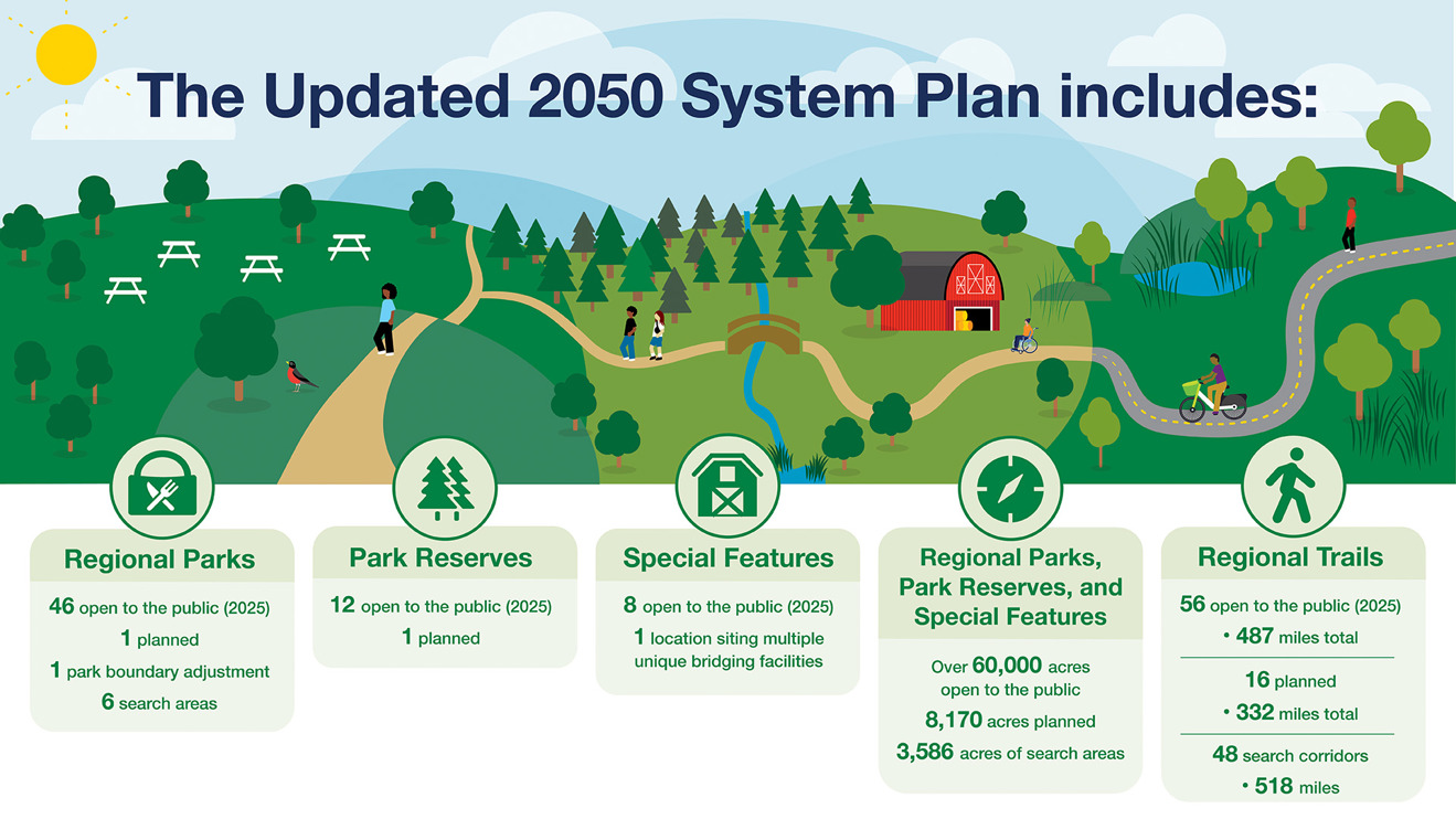
Figure 2.8: 2050 Regional Parks and Trails System Plan Map*

Estimated cost to implement the system plan
State law requires that the regional parks policy plan estimate the cost of the recommended acquisitions and development of the park system, including an analysis of what portion of the funding is proposed to come from the state and Met Council levies, and other local government units (Minn. Stat. 473.147, subd. 1). The following analysis is an estimate of funding required to complete the system.
The estimated cost to complete the existing Regional Parks and Trails System is $2.99 billion, including $1.08 billion in acquisition costs and $1.91 billion in development costs (Table 2.11).
| Category | Acquisition Cost | Development Cost | Total Cost |
| Unbuilt portions of existing regional parks and trails | $777,429,000 | $986,715,000 | $1,764,144,000 |
| Planned regional parks and trails | $87,447,000 | $146,053,000 | $233,500,000 |
| Boundary Adjustments, Park Search Areas and Corridors | $140,021,000 | $104,500,000 | $244,521,000 |
| Regional Trail Search Corridors | $72,168,000 | $671,241,000 | $743,409,000 |
| Total | $1,077,065,000 | $1,908,509,000 | $2,985,574,000 |
Purpose and use
This estimate is intended to fulfill the state requirement for a metro-wide cost to complete the Regional Parks and Trails System. This is a high-level estimate that demonstrates the scope of the future development and acquisition plans for the system.
The estimate is not intended to indicate costs for any single project or implementing agency.
Methodology
The Met Council refined the approach from the 2020 update to use the most recent and available data related to cost estimates within the Regional Parks and Trails System. The Met Council worked with implementing agency staff to identify and confirm the cost components, data sources, assumptions and results.
The Regional Parks and Trails System Plan includes regional parks, park reserves, special features, and regional trails in various degrees of completion:
- Already in use (which may include additional unbuilt or unacquired elements)
- Planned or acquired but not yet open to the public
- Yet to be acquired and developed search areas
Acquisition costs
Land acquisition costs were calculated by summarizing the county assessor’s total estimated market value for properties that are identified as inholding parcels. Where individual parcel data was not available, such as parks search areas and trail search corridors, average per-acre costs were used for parcels inside the Metropolitan Urban Services Area (MUSA) and outside the MUSA. The provision of wastewater service is not the only factor contributing to higher land values in the region’s core. Other locational attributes that matter for land values are spatial situation (centrally located or remote), accessibility to employment centers and other destinations, proximity to lakes and rivers, neighborhood amenities, and other urban services (for example, high frequency transit service).
Development costs
Development costs for parks and trails already in use or planned but not yet open to the public were derived from cost estimates included in long-range plans. The cost estimates included in long-range plans define the development needs specific to each unit. Cost estimates were updated to current dollars using the Consumer Price Index (CPI). Implementing agencies provided an estimated percentage of completion for each park or trail unit. The inverse percentage needed to complete the unit was applied to the long-range plan estimate to calculate future development cost.
Development costs for search areas and corridors were estimated by respective implementing agencies.
Limitations
The estimate is intended for use only at a regionwide level. Application to an individual project or single implementing agency is inappropriate. Actual costs for individual projects will vary depending on the location and complexity of each project. Refer to long-range plans, project funding applications, and recent construction for more information on project costs. Lastly, this calculation is completed with current cost estimates and market values. Factors such as changing long-range plan timelines, inflation, and market drivers affect the actual cost of future development and acquisition.
Analysis
Total acquisition and development costs to complete the Regional Parks and Trails System are nearly $3 billion, including $1.76 billion for the unbuilt portions of the existing parks and trails, $234 million for planned units, and $988 million for search areas and corridors (Figure 2.8). Table 2-12 shows acreage, mileage and costs associated with each category.
| Category | Park Acreage | Trail Acreage | New Trail Mileage | Acquisition Cost | Development Cost | Total Cost |
| Unbuilt Portions of Existing Regional Parks, Park Reserves, Special Features, and Regional Trails (Figure 2.9) a. | 2,785 | 2,621 | 250 | $777 million | $987 million | $1.76 billion |
| Planned Regional Parks, Park Reserves, Special Features, and Regional Trails (Council-approved long-range plan, not yet open to the public) (Figure 2.10) a. | 3,383 | 248 | 122 | $87 million | $146 million | $234 million |
| Regional Park Search Areas and Boundary Adjustments (Figure 2.11) b.c. | 3,586 | N/A | N/A | $140 million | $105 million | $245 million |
| Regional Trail Search Corridors (Figure 2.11) b.c. | N/A | 896 | 534 | $72 million | $671 million | $743 million |
| GRAND TOTAL | 9,754 | 3,765 | 906 | $1.08 billion | $1.91 billion | $2.99 billion |
Data Sources:
a Council approved long-range plans
b 2040 Regional Parks Policy Plan (2018)
c Estimates from regional park implementing agencies

Capital improvement plan
As directed by Minn. Stat. 473.147, subd. 1, the regional parks policy plan must include a five-year capital improvement plan (Table 2.13). These figures are subject to change based upon legislative action. The projections are provided by the park agencies and are based on their current estimate of funding levels.
Table 2.13: Regional Parks and Trails System Five-Year Capital Improvement Plan, 2025-2029 (in millions)
| Funding Source | 2025 | 2026 | 2027 | 2028 | 2029 | Total |
|---|---|---|---|---|---|---|
| Regional | $12.0 | $2.6 | $9.3 | $3.0 | $9.0 | $35.8 |
| State | $73.9 | $43.7 | $102.6 | $42.8 | $99.4 | $362.3 |
| Other a. | $52.4 | $25.5 | $46.1 | $20.3 | $33.1 | $177.5 |
| Total | $138.2 | $71.8 | $158.0 | $66.1 | $141.5 | $575.6 |
a.”Other” includes all other sources of funding invested in the system by implementing agencies including local, federal, etc.
| Use of Funds | 2025 | 2026 | 2027 | 2028 | 2029 | Total |
|---|---|---|---|---|---|---|
| Expansion | $8.7 | $7.6 | $7.9 | $7.6 | $7.9 | $39.8 |
| Improvements | $76.6 | $36.1 | $63.9 | $25.3 | $49.6 | $251.4 |
| Preservation | $52.9 | $28.1 | $86.2 | $33.1 | $84 | $284.4 |
| Total | $138.2 | $71.8 | $158.0 | $66.1 | $141.5 | $575.6 |
