Bicycle Investment Plan
Table of Contents
Introduction
Bicycling is an essential travel mode in our regional transportation system that provides many local and global benefits. It allows people to leave their cars at home to make daily trips without adding greenhouse gas emissions that contribute to climate change. Riding a bike for commuting to work or school, running errands, shopping, or visiting friends provides opportunities for people to include physical activity in their daily travel routines, thereby affording them the physical and mental health benefits biking provides.
In addition, regular use of bikes for travel can reduce a household’s transportation costs. For some people, bicycling may be the only affordable option given the relatively high cost of owning an automobile or due to limited transit options available. Bicycling also allows people to connect with buses or trains. This makes longer trips possible to more distant destinations that are more often accessed by personal automobiles.
It is also important to note that investment in bicycle infrastructure often leads to higher sales and property values in well-traveled areas. Premium trail facilities can have dramatic economic benefits: The 8-mile cultural trail into downtown Indianapolis was the central component of $63 million in city investments that contributed to a nearly 2.5 times increase in assessed property values within one block of the trail.125
The availability of safe, continuous, and comfortable bicycle facilities plays an important role in people’s decisions to ride bicycles. Lack of such facilities is often cited as a top reason for choosing other modes of travel in user surveys. In response to this concern, local agencies are planning protected bikeway networks that physically separate bicyclists from street traffic. (The cities of Minneapolis and Saint Paul are planning and building extensive protected bikeways, to name two prominent examples.)
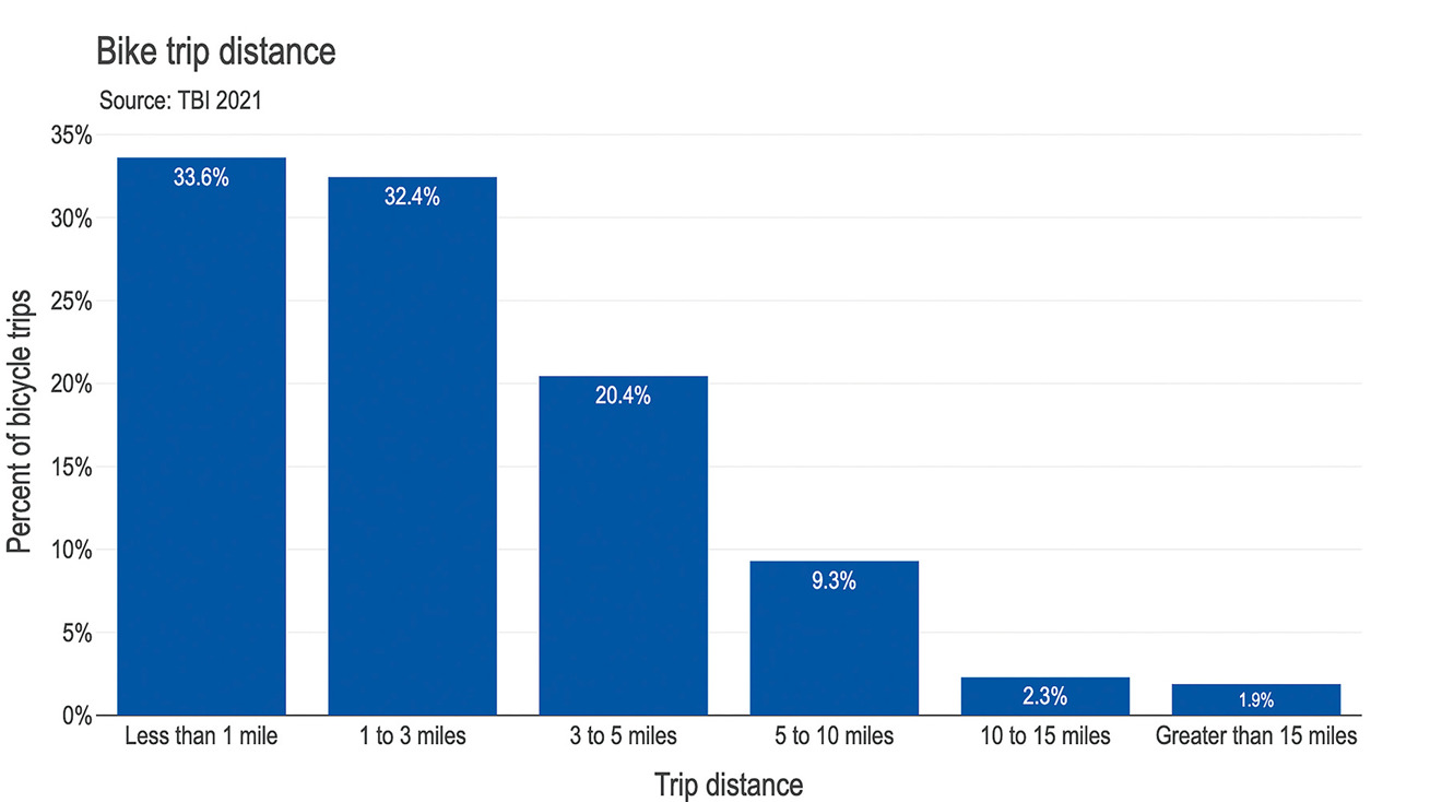
Notwithstanding this concern, bicycling has good potential to replace car trips for personal daily travel. The National Household Travel Survey found that nearly half of daily trips taken in the United States across all transportation modes were within three miles, or a 20-minute bike ride. This is consistent with regional data shown in Figure 10.1 that indicate about three out of four bike trips are three miles or less. The average bicycle trip length in the seven-county metro region is about 2.9 miles, according to data from the 2021 Travel Behavior Inventory. For these shorter trips, bicycling can often provide the shortest travel time of any mode, particularly during congested times. Biking can also provide reasonable travel times for longer trips (about one out of four of all trips are greater than three miles), especially when using electric bikes and/or combining with transit.
Figure 10.1: Bicycle trip distances for Twin Cities region, from 2021 Travel Behavior Inventory
Regional and local transportation planning must consider both short- and long-range bicycle trips to maximize the possible environmental and health benefits of bicycling.
Met Council roles in regional bicycle planning
The Met Council assists in planning for the development of bikeway networks and multiuse trails for bicycling. The Met Council’s roles with respect to regional bicycle planning include:
- Planning regional bicycle networks to serve regional travel needs. Ensuring continuity and connectivity between regional destinations and regional networks and local bicycle networks is an essential aim.
- Identifying regional barriers to bicycling and working with state and local partners through coordinated planning to determine solutions.
- Providing guidance for evaluating bicycle facilities seeking regional funding, through the Livable Communities Act, Regional Solicitation, and active transportation programs.
- Providing guidance for other investment programs that impact bicycling or provide opportunities to add or enhance bicycle facilities, such as regional transit projects or highway corridor improvement projects.
- Providing guidance to local comprehensive plans to ensure that bicycle needs are considerations for land use and transportation planning and for reviewing how local networks connect to regional networks and regional destinations.
- Providing technical assistance and funding support to regional park implementing agencies for planning, developing, operating, maintaining, and acquiring land for regional trails.
Relationship to 2050 goals and objectives
Planning for and investing in bicycle infrastructure supports the region’s goals and related Transportation Policy Plan objectives. This section highlights how the region’s goals developed for Imagine 2050 relate to bicycle system planning. Each goal section describes how work carried out in response to this plan should help to advance the transportation plan objectives quoted below.
Our region is equitable and inclusive
Through the application of equity and inclusion principles in planning and developing continuous facilities on interconnected regional and local bicycle networks, the region can ensure that “historically disadvantaged communities are better connected to jobs, education, and other opportunities” and that bicycle facilities and the connections they provide will “better meet the transportation needs of people who have disabilities.” Biking is also a more affordable option than owning a car and good bicycle networks can provide improved mobility for households that may not be able to afford a personal vehicle or other more expensive forms of transportation.
Our communities are healthy and safe
As a region we should purposely plan, design, and implement bicycle infrastructure facilities in ways that make “people feel safer, more comfortable, and more welcome” when riding bicycles. By applying this basic principle in the planning and design process, more desirable and effective facilities will expand opportunities where “people can increase physical activity with more opportunities to walk, roll, or bike.” Well-designed facilities protect people on bikes, who are more vulnerable to serious injuries and deaths when not separated from vehicle traffic.
Our region is dynamic and resilient
Planning and continuing to develop regional and local bicycle networks to connect with the regional transit system and important daily destinations helps ensure we “can better meet [people’s] daily needs with reliable, direct, and affordable options beyond driving alone.”
We lead on addressing climate change
Providing well planned and prioritized bicycle facilities, which includes designing facilities that are safe, comfortable and inviting, will play an important role in helping “the region’s transportation system minimize its contributions to climate change” and in meeting the 2050 regional target to “reduce vehicle miles traveled by 20% per capita below 2019 levels.”
Existing Bicycle System
This existing bicycle system section discusses bicycle facilities, shared mobility options and mobility hubs, and the implications of the growing use of electric bikes.
Existing bicycle facilities
The region’s bicycle facilities consist of:
- Regional trails designated in the Regional Parks Policy Plan and developed and maintained by regional park implementing agencies.
- Local on-road bikeways and off-road multiuse trails that cities, counties, and/or MnDOT are responsible for planning, developing, and maintaining.
- Several state trails in the metro region developed and maintained by the Minnesota Department of Natural Resources.
The Twin Cities region has a well-developed system of on-street and street-adjacent bicycle facilities in the urban core and suburban cities, alongside a widespread network of off-road trails throughout much of the region. Over time, the region’s investments in bicycle-friendly infrastructure have supported Minneapolis and Saint Paul to a level that led to their ranking first and seventh, respectively, among large cities nationwide in the advocacy group People for Bikes’ “2023 Best Places to Bike” ratings.
For more than a century a system of regional trails has been developed to extend beyond the core cities of Minneapolis and Saint Paul. The system provides paved and mostly off-road trails between our many regional parks. As the Twin Cities were early adopters and implementors of bicycle infrastructure, there is a growing need to replace multiuse trails that were built 30 or more years ago. As the system continues to age, the importance of investing in facility reconstruction projects will also grow.
Many of these trails parallel the region’s rivers and streams, adding scenic beauty to the cycling experience. Other trails along abandoned rail lines provide more direct cycling routes into the core cities’ downtowns or between suburban centers. There are currently more than 400 miles of off-road, paved bicycle trails along 55 designated regional trails across the Twin Cities region. Together, these trails serve more than 20 million visitors annually.
The region’s existing on-road bicycle facilities have been designed and developed to include a range of characteristics. Bicycle facilities have been implemented along all roadway types in the form of adjacent-street shared-use trails, separated bicycle facilities, conventional and buffered bicycle lanes, bicycle boulevards, and designated bike routes with continuous paved shoulders. Typical bicycle transportation routes may include one or several of these facility types. (See also facility type descriptions under Facility types that meet Regional Bicycle Transportation Network functionality, later in this plan.)
A growing number of separated bikeways have been constructed or are planned in Minneapolis, Saint Paul, and in suburban cities such as Edina and Richfield. Separated bikeways are street or sidewalk-level bicycle facilities physically separated from lanes of vehicle traffic. They are most commonly designed for exclusive use by people who bike or use electric scooters or other rolling conveyances. Separated bikeways are physically separated from general traffic lanes by vertical elements such as plastic pylons, concrete bollards, or elevated curbs and include protected bike lanes and cycle tracks. Separated bikeway networks are intended to provide a safer and more comfortable user experience that can attract and serve people of all ages and abilities.
Regional Bicycle System Inventory
The Regional Bicycle System Inventory was compiled with the help of the seven metro region counties and their member cities by combining available local bike plan data into unified county datasets. The Met Council then assembled a unified regional dataset that includes most cities with existing bike plans. The purpose of the inventory is to assist local and state planning agencies to update bicycle plans or review regional and adjacent city plans. It is also used to help identify potential alignments to be designated as official alignments within Regional Bicycle Transportation Network corridors. The inventory was developed in late 2016 and as more cities and counties have developed bicycle plans and continue to construct more bicycle facilities, an update is slated in the 2024-2025 timeframe. The data are included within the Regional Bicycle Transportation Network online map application. Table 10.1 shows the total regional bicycle system mileage by existing and planned status for all local, state, and regional bicycle facilities.
Table 10.1: Regional bicycle system mileage summary
| Bikeway status | On-street | Off-street | Undefined | Total |
|---|---|---|---|---|
| Existing | 1,880 | 2,030 | NA | 3,910 |
| Planned | 1,030 | 820 | 1,010 | 2,860 |
| Total | 2,910 | 2,850 | 1,010 | 6,770 |
Note: As initially compiled by Met Council from Regional Bicycle System Inventory, 2016.
Shared mobility options and mobility hubs
The term shared mobility refers to a set of transportation resources that are shared among users and are typically designed to function on technology-enabled platforms (meaning, they will work with a smartphone). Shared mobility is distinct from traditional transportation services in that it is technology-enabled and supports real-time travel needs by providing flexible options to match customer preferences. Shared mobility services have developed and evolved in large part due to private sector innovation and entrepreneurship aimed at extending the reach of and filling gaps in traditional fixed-route transit service. Private transportation network companies like Uber and Lyft were major developers of ride-hailing programs designed to connect passengers with drivers in real time. Companies like Lyft and Lime were leaders in developing e-bike and e-scooter operating systems, and Lime continues to provide bikeshare service in Minneapolis and St. Paul.
Shared mobility encompasses a wide range of transit, micromobility, and ride-hailing services available in the Twin Cities including:
- Public transit services (see Transit Investment Plan)
- Fixed-route transit
- Dial-a-ride (Metro Mobility, Metro Move, Transit Link)
- Microtransit (online platforms assign passengers to vehicles for six or more riders)
- Vanpooling (Metro Vanpool)
- Micromobility
- Bikeshare (e-bike short-term rental such as LimeBike, Zeo)
- E-scooter share (e-scooter short-term rental, like Lime, Bird)
- Carshare (auto rentals for less than one day like Evie and HOURCAR)
- Carpooling
- Taxis
- Ride-hailing and transportation network companies (Uber, Lyft)
Twin Cities Shared Mobility Action Plan
In 2017, a coalition of regional stakeholders developed the Twin Cities Shared Mobility Action Plan. This initial plan was aimed at improving coordination of shared mobility services toward achieving two goals:
- Reduce single-occupant vehicle use by removing 50,000 cars a day from the region’s roads within 10 years.
- Ensure the equitable deployment of shared mobility options that serve the public transit market.
The regional stakeholders group evolved to become the Twin Cities Shared Mobility Cooperative to advance these shared mobility goals through implementing the action plan. In 2023 this group was expanded and redefined with a statewide focus as the Minnesota Shared Mobility Collaborative. The collaborative is guided by a steering committee and is currently staffed by the University of Minnesota Center for Transportation Studies.
From the Shared Mobility Action Plan vision, Metro Transit created the Shared Mobility Strategy (2019) to guide the Met Council’s efforts in pursuing shared mobility integration. The strategy developed the overall Shared Mobility Program goal of “enabling more people to travel without the need for a personal automobile.” In support of this goal, the strategy further supports “transportation system integration and seamless connectivity for users.”
Metropolitan Council Mobility Hub Planning and Implementation Guidebook
Metro Transit’s Shared Mobility Strategy identified shared mobility hub planning, development, and implementation as key steps toward achieving its goals. Shared mobility hubs are places where people can connect with multiple modes of transportation in a safe, comfortable, and accessible environment, facilitating convenient and reliable travel. The purpose of mobility hubs is to co-locate diverse transportation options with community amenities to help people access shared vehicles, connect between travel services, and/or orient themselves when they arrive. These hubs are designed to be accessible and inclusive spaces for people to experience simplicity in planning their multimodal trips.
As a continuation of the work identified through the shared mobility strategy, the Mobility Hub Planning and Implementation Guidebook was created in 2022 to provide guidance to the region’s communities and public agencies for advancing mobility hubs from concept and planning to implementation and management. Through the planning process, Met Council worked with regional partners to identify the 50 top regionally significant mobility hub locations across the region. More information on this initiative, including the prioritized shared mobility hubs, is available on the Mobility Hub Planning Guide web page.
The purchase and use of electric bicycles, or e-bikes, are on the rise in the Twin Cities region as they are seen on local streets and trails with growing regularity. E-bikes are popular because they’re easy to operate and require less physical exertion, which allows for longer trips and trips over hillier terrain than with a traditional bicycle. Their growing presence in the region suggests a trend similar to the continuing rapid growth observed in e-bike purchases in the United States.
Although e-bike sales statistics specific to Minnesota were not available, there has been anecdotal evidence of rapid growth in the public’s interest and purchases of e-bikes. One 2023 Minnesota Public Radio article generally noted that bicycle retailers in Minnesota have been seeing a surge in e-bike sales in recent years and have been experiencing an uptick in e-bike inquiries since the legislature passed the e-bike purchase rebate program in 2023. The same article also reported that one major bicycle retailer had seen an annual doubling of e-bike sales over several years to where it made up more than half of the retailer’s overall dollar sales in 2023 across its 32 stores in Minnesota and the Midwest.126
Figure 10.2: Advantages of electric bikes

Nationwide, there were 1.1 million e-bikes sold in the U.S. in 2022, up from about 325,000 purchases in 2018,127 and representing nearly a four-times factor jump in four years. An e-bike industry analysis projects e-bike sales in the United States to grow from just under $2 billion in 2022 to more than $7 billion in 2030.128 Given these national growth statistics and local qualitative evidence in e-bike sales growth, it is likely that e-bike usage in this region will continue to grow in the foreseeable future.
E-bikes offer a host of benefits to the consumer, not the least of which relates to their relative affordability. The upfront cost of e-bikes has decreased in recent years with prices as low as $1,000 for a basic new e-bike. Although these prices will remain unaffordable for some, an e-bike’s relatively low maintenance costs can offset their purchase price and save money in the long run, especially when compared to the high costs of owning and driving an automobile. Starting in 2024 Minnesota resident taxpayers are able to receive a discount of up to 75% off a new e-bike purchase through a new state rebate program (discount capped at $1,500), perhaps making e-bikes an affordable option for more residents.129 This program is currently funded through June 2026.
Local governments can also provide e-bike stimulus programs in addition to what is available from the state. There are e-bike stimulus programs initiated by local city governments around the nation that are good examples for the region’s cities to consider. The Atlanta Regional Commission partnered with the City of Atlanta to develop the equity-focused Atlanta E-Bike Rebate Program. The City of Denver also created an E-Bike Rebates Program that is scaled based on levels of income and includes bump-ups in the total rebate amounts for people with disabilities using adaptive bikes and for cargo e-bike purchasers.
There are growing safety concerns around potential conflicts due to the speed differential between e-bikes and standard bicycles that could affect users of all surface transportation modes. Conversations on e-bike safety will be important to have among regional transportation partners and other state/local agencies with implications relating to design standards, regulation, and enforcement. The Met Council's role will be to convene meetings and facilitate discussions among agencies more closely tied to these planning and policy areas, which can begin in 2025. Although there are some risks for new e-bike riders due to potential overconfidence in their abilities to maneuver a powered bicycle, bicycling via e-bike can be made safer through advance-obstacle or oncoming-vehicle warnings as newer smart technologies are incorporated into e-bike designs.
What e-bikes could ultimately mean for regional and local bicycle planning remains to be determined, but a few changes can be seen about how people use e-bikes now and into the future:
- Upper age limits for healthy biking are being extended because the physical demands of biking are lessened by e-bikes.
- Bicycle trip distances will likely increase due to higher average speeds with less energy expended (a research study of e-bike versus nonelectric bicycle trip behavior found that average trip distance for e-bikers nearly doubled, as did daily bike distance traveled when including trips via both bike types for e-bikers compared to traditional bicyclists130).
- More demand for on-street and off-street bicycle facilities will likely result, including demand for more bicycle-specific investments that offer full separation from vehicle traffic.
- Daily bicycle routes may become more direct in areas where hills were a constraint to route choice, now that anyone with an e-bike can ride with ease over long or steep hills.
- The need to manage speeds along bicycle facilities and to provide separation between people biking and rolling, pedestrians, and potentially e-bikes may grow due to the widening range of moving speeds introduced with more e-bikes.
- Cargo e-bikes will provide additional opportunities to reduce vehicle miles traveled and greenhouse gas emissions through performing last-mile deliveries to consumers and businesses for more details on how cargo e-bikes can be incorporated into e-commerce freight delivery systems).
Most importantly, demand for e-bicycles may increase and continue to compete with automobiles for more and longer trips than traditional bicycles. E-bicycling, given its longer range of travel, could become a bigger factor in lower-density suburban and rural areas where biking hasn’t been seen often as a viable option in the past. This has great potential to reduce vehicle miles traveled by gasoline and diesel-fueled automobiles with reductions to associated greenhouse gas emissions. This benefit of increasing e-bike usage also extends to trips taken by electric vehicle, though to a lesser degree. E-bikes operate with zero emissions but also produce a much smaller carbon footprint in their manufacturing process compared to electric vehicles. Thus, in the near future, e-bikes may have an equal or even greater role than electric vehicles in fighting climate change in this region and beyond.
Bicycle Investment Plan
Regional investments for bicycle infrastructure are determined by the Transportation Advisory Board through the Regional Solicitation for federal transportation funds administered by the Met Council. Other federal, state, and local funding sources are discussed later in the funding programs section. In addition to the Regional Solicitation, a new regional sales and use tax for active transportation was passed by the state legislature in 2023. This new active transportation fund is estimated to provide an additional $24 million per year to fund bicycle and pedestrian projects in this region. This annual infusion of funds may facilitate building out better connected and more continuous local and regional bikeway networks. It may aid local governments who have been constrained by limited funds and have only been able to construct discrete segments of bikeways that are less than ideal for transportation and recreational trips. More details on this funding source are discussed in the funding programs section.
This section of the plan gives direction for planning, implementing, and prioritizing bicycle system improvement projects. Bicycle planning, facility design, and project selection for transportation funding are driven by a set of key factors that often are mirrored in bicycle study analyses and facility type selection processes. Minimizing the risk of crashes and providing a level of comfort and convenience to attract and serve a wide range of rider experience levels, ages, and abilities, are top considerations in planning bicycle facilities. Other important factors typically include:
- Network connections to transit and regional and/or local destinations.
- Social and economic equity factors that account for and work toward rectifying economic and racial or ethnic disparities.
- Potential bicycle trip demand based on factors like future population and employment density and proximity to major destinations.
Through several regional studies, these factors have been used to establish three useful planning and investment prioritization tools: the Regional Bicycle Transportation Network, regional bicycle barriers with their integrated barrier-crossing opportunity areas, and major river bicycle barrier crossings. This section includes guidance on how to apply these tools for prioritizing the region’s bicycle infrastructure investments. References to detailed technical information are provided through links to the underlying regional planning studies, state and federal design guides, and interactive online maps and tools. For more information on regional investment priorities, also see other key bicycle system investment factors at the end of this section.
The Regional Solicitation Evaluation study will be analyzing similar factors and project selection criteria to determine how they influence regional transportation investments and to what extent they reflect and advance regional transportation goals. Results of the evaluation may include adjustments or additions to the criteria and analysis factors (which also have been applied in regional and local bicycle studies over time). MnDOT’s Suitability of Pedestrian and Cycling Environments is another planning tool that complements the regional tools and may be helpful to local agencies in planning their local networks.
Regional Bicycle Transportation Network
The Regional Bicycle Transportation Network is the established regional network that is used by the region as a planning and investment tool. This section describes the network’s purpose and goals and documents its foundational guiding principles. Following this introductory background are detailed discussions of network corridors, alignments and priority tiers, the specific definitions and thresholds for the network’s regional destinations, and the interrelationship of the network and regional trails. The section concludes with general guidance for local and state practitioners on planning and implementing bicycle facilities on the network, and the process for updating Regional Bicycle Transportation Network corridors and alignments.
Description and purpose
The Regional Bicycle Transportation Network was adopted into the Transportation Policy Plan in 2015 as the official regional bikeways network that sets the region’s priority vision for planning and investment. The network is based on a Regional Bicycle System Study analysis and prioritization of potential corridors that includes factors such as bicycle trip demand, network connectivity, social equity, population and employment density, and connections to transit. Read more details of the Regional Bicycle System Study.
The purpose of the Regional Bicycle Transportation Network is shaped by the following goals:
- Establish an integrated and seamless network of on-street bikeways and off-road trails.
- Provide the vision for a “backbone” arterial network to serve daily bicycle trips by connecting regional destinations and local bicycle networks.
- Encourage cities, counties, park agencies, and the state to plan and implement future bikeways in support of the network vision.
In support of these overall goals, cities and counties are encouraged to plan and implement the regional bicycle network and its connections to local bicycle networks through local comprehensive, transportation and/or bicycle-specific plans. The Regional Bicycle Transportation Network is one of multiple factors used in the Regional Solicitation process to select projects for receiving federal transportation funds. (See also regional, state, and local programs in the funding programs section below for details on this and other state and federal funding opportunities to support local projects.)
Guiding principles
A set of guiding principles was used to develop the Regional Bicycle Transportation Network by identifying regional bikeway corridors that would:
- Overcome physical barriers and eliminate critical system gaps. Specifically addressing gaps and barriers in the regional system will improve convenience and continuity for bicyclists.
- Facilitate safe and continuous trips to regional destinations. Developing and upgrading bicycle facilities along the network will improve the convenience and safety of bicycling along these facilities.
- Function as arteries to connect regional destinations and the transit system year-round. Designating alignments within network corridors and implementing bikeways on the network will provide the needed connections to regional destinations and the regional transit system.
- Accommodate a broad range of cyclist abilities and preferences to attract a wide variety of users. Bicyclists have varying levels of comfort to ride based on facility type (on-street facility vs. off-road trail), roadway characteristics, and personal levels of experience and ability. In some urban, high-demand corridors it may be appropriate to develop both an on-street facility and an off-road trail to accommodate the full range of cyclist preferences.
- Integrate and/or supplement existing and planned infrastructure. When developing the Regional Bicycle Transportation Network, existing and planned infrastructure should be used when possible to reduce the need to purchase new right-of-way and to minimize the growing financial burden of preserving and maintaining existing facilities.
- Provide improved opportunities to increase the share of trips made by bicycle. Implementing a complete network that provides convenient connections to designated regional destinations and the regional transit system will increase the likelihood of choosing bicycling for transportation over other travel modes.
- Connect to local, state, and national bikeway networks. Connecting to other established bicycle networks will expand the reach and effectiveness of the regional network.
- Consider opportunities to enhance economic development. New bicycling investments can be an effective tool for creating local economic development opportunities and to foster the Twin Cities region’s image as highly livable with many bike-friendly destinations.
- Be equitably distributed throughout the region. Social equity and regional geographic balance were emphasized in designating the Regional Bicycle Transportation Network. By focusing on population and employment concentrations, the network will be able to attract the greatest number of riders. By also considering areas where more people live with lower incomes and where more people of color live and work, the network will offer equitable access to bicycling facilities and the economic opportunities and health benefits afforded by bicycle infrastructure.
- Follow spacing guidelines that reflect established development and transportation patterns. The Regional Bicycle Transportation Network corridors were developed in a way that applied spacing concepts based on urban and suburban development patterns and plans. The resulting network is denser and has greater accessibility compared to regional bikeway corridors found in other metropolitan regions.
- Consider priorities reflected in adopted plans. The Regional Bicycle Transportation Network was developed to reflect local bicycle plans and policies that inform regional priorities.
Regional Bicycle Transportation Network elements
Corridors, alignments, and priority tiers
Figure 10.3 shows the Regional Bicycle Transportation Network of corridors and alignments. Network corridors are established where there is existing or potentially high bicycle trip demand between regional network-designated regional destinations, major activity centers, and moderate-to-higher density local neighborhoods or commercial areas. Corridors reflect where alignments have not yet been identified. The presence of corridors allows for local planning processes to determine the most appropriate alignment that follows the directional orientation of the corridor and combines on-street bikeways with off-road trails, where appropriate.
Regional Bicycle Transportation Network alignments are defined where there are existing or planned bikeways, or in the absence of these, a consensus of which road or roadways would most efficiently meet the regional corridor’s intent. When these conceptual planning alignments are identified within an existing corridor by the local jurisdiction, the original corridor will dissolve and be replaced by the alignment on the network map. Corridors and alignments are classified as Tier 1 or Tier 2 priorities, with Tier 1 representing the region’s highest priorities for bikeway planning and investment. Tier 1 corridors and alignments are planned in locations where they can attract the most riders and where they can most effectively enhance mode choice in favor of biking, walking, and transit over driving alone. For more detail, see the interactive online map.
Figure 10.3: Regional Bicycle Transportation Network
![]()
In order to advance the Regional Bicycle Transportation Network vision to create the “backbone arterial network to serve daily bicycle trips by connecting regional destinations and local bicycle networks,” projects that enhance existing or complete new segments of the network should be given priority for federal transportation funding. As identified in Figure 10.3, the network is divided into two priority tiers:
- Tier 1 Regional Bicycle Transportation Network Corridors and Alignments should be given a high priority for transportation funding. These are the established corridors and alignments that provide the highest potential bicycle transportation function by connecting regional destinations and major activity centers with local bicycle networks.
- Tier 2 Regional Bicycle Transportation Network Corridors and Alignments should be given a moderate-to-high priority for transportation investment. These corridors and alignments provide transportation connectivity to more outlying regional destinations and serve to connect Tier 1 regional bicycle transportation corridors and alignments.
Regional destinations
Regional destinations are included in the Regional Bicycle Transportation Network to define the major development and activity nodes between which the network is intended to provide connections. These are currently defined in the network map legend (see Figure 10.3) and include the following:
- Major employment centers131 (minimum density of 10 jobs per acre)
- Metropolitan job centers (greater than 50,000 jobs)
- Regional job centers (15,000 to 50,000 jobs)
- Subregional job centers (7,000 to 15,000 jobs)
- Universities and colleges (at least 2,000 students)
- Large high schools (at least 2,000 students)
- Major sport and entertainment centers
- Highly visited regional parks (more than 400,000 annual visits)
Several new sports venues have been constructed in recent years that are deemed worthy of regional destination status, including Allianz Field in Saint Paul and the Vikings’ headquarters and TCO Stadium in Eagan. In addition, regional transit nodes were an important determinant of the original Regional Bicycle Transportation Network corridors created through the Regional Bicycle System Study. Therefore, to update the network to the latest state of constructed and planned sports stadiums and regional transitways, the following transportation nodes are new network regional destinations:
- Allianz Field soccer stadium in Saint Paul
- Minnesota Vikings TCO Stadium in Eagan
- All existing and planned rail transit stations
- All existing and planned bus rapid transit stations
Regional Bicycle Transportation Network relationship to regional trails
In practice, the Regional Bicycle Transportation Network, regional trails, and all local trail and bikeway networks complement each other to serve the overall bicycle transportation and recreation needs of the region. All of these elements serve to provide an integrated and cohesive system that supports all forms of bicycling and the full range of bicycle trip needs.
Regional trails were an important input during the development of the original Regional Bicycle Transportation Network, and many regional trails have been identified as important alignments within it. While there is significant overlap between the two networks, there are also some distinct differences. The Regional Bicycle Transportation Network is planned to facilitate daily bicycling for transportation, including commute trips to work and school, shopping trips, trips to entertainment venues, medical-related trips, and social trips. In contrast, regional trails are planned and designed more from a recreational perspective.
The Regional Bicycle Transportation Network values trip efficiency over route aesthetics. It focuses on connecting its designated regional destinations to and between local bicycle networks by integrating on-street bikeways and off-road trails that offer the most direct and efficient routes. For regional trails, the planning philosophy is more focused on providing connections between regional parks, mainly by developing off-road facilities that are routed to provide scenic value over route efficiency. Many regional trails also serve as significant and highly used bicycle transportation corridors as evidenced by their inclusion on the Regional Bicycle Transportation Network.
Although not the main focus of the Transportation Policy Plan, recreational bicycling is significant to the region. It represents an important entry point for many cyclists to become familiar with bicycling in general, and how to navigate between bicycle facilities on lower-volume streets and trails. Ultimately, many recreational cyclists will become users of these systems for a variety of transportation purposes.
An integrated system of regional trails and the Regional Bicycle Transportation Network requires a collaborative approach to regional trail and bicycle transportation planning by the Met Council and its agency partners. The Met Council is committed to continued participation in meetings with regional park and trail implementing agencies and will facilitate broader meetings, as needed, to enhance collaboration and coordination among transportation and parks agency planners toward maintaining and building a cohesive and integrated regional bicycle system overall.
Regional Bicycle Transportation Network planning and implementation guidance
Because the Regional Bicycle Transportation Network has been the established regional network since 2015, it is appropriate to continue monitoring progress on its implementation. Table 10.2 shows the estimated centerline miles of existing and planned Regional Bicycle Transportation Network alignments and/or corridors and their corresponding percentages of total network centerline miles. These totals include all recent network updates further described under the “Regional Bicycle Transportation Network update process” section below.
Figure 10.4: Total RBTN centerline miles

Table 10.2: Regional Bicycle Transportation Network implementation status
| Network facility status | On-street | Off-street | Undefined | Total | % planned | % total |
|---|---|---|---|---|---|---|
| Existing bikeways (alignments) | 199 | 649 | 0 | 848 | 53.3% | |
| Planned bikeways | ||||||
| Network alignments | 64 | 159 | 61 | 284 | 38.2% | |
| Network corridors | NA | NA | 460 | 460 | 61.8% | |
| Total planned bikeways | 64 | 159 | 521 | 744 | 100% | 46.7% |
| Total network centerline miles | 263 | 808 | 521 | 1,592 | 100% |
Note: Table values are in miles based on Met Council-estimated Regional Bicycle Transportation Network centerline miles.
Local planning for Regional Bicycle Transportation Network corridors and alignments
The broad Regional Bicycle Transportation Network corridors shown in Figure 10.3 (one-mile wide in suburban and rural areas, one half-mile wide in the core cities) are intended to allow flexibility among local government agencies to tailor specific alignments for bikeway facilities through the local planning process. As specific alignments that run within and along the corridors are designated through the local planning process, the regional corridor will be replaced on the Regional Bicycle Transportation Network map with the preferred alignment. These new alignment designations are periodically added to the Regional Bicycle Transportation Network map as an administrative task and do not require a formal Transportation Policy Plan modification or amendment.
The goal of providing continuity of regional bicycle corridors and facilitating direct access to corridor destinations may be reached by building safe and comfortable bicycle facilities along roadway corridors. Planning for cyclists’ comfort and convenience across a wide range of experience levels, ages, and abilities is an important focus for any major roadway project. Other priorities, including safety for all users, mobility for all transportation modes, and corridor aesthetic enhancements (like open space, trees, or other corridor greening features) should also be considered. Prevailing vehicle speeds and volumes in adjacent traffic lanes are paramount safety-related considerations in the design and implementation of on- or off-street bicycle facilities.
Some highways serve as the only practical and effective crossing over a major barrier (such as rivers, freeways, multi-lane highways, and railroad corridors). In these cases, safe bicycle accommodations should be provided on the highway segment that crosses over (or under) the barrier. On some other highway segments not crossing a barrier but having high traffic volumes, an intensive mix of trucks and buses, and limited right-of-way to provide designated bicycle facilities, it may be appropriate to route the facility away from the highway when a nearby, parallel local street is available. This condition occurs more frequently on A-minor arterials in highly developed urban corridors than on A-minors in less developed, suburban, or rural corridors. However, this will not always be the case, and each corridor should be planned to address its unique issues and needs from both a local and regional perspective.
As an alternative to locating regional bikeways along major highways, regional transportation partners can also plan and build new, continuous bicycle facilities that cross barriers via the local street system. With their lower traffic volumes and slower speeds, local streets can be improved to serve a broader range of cyclist ages and abilities. These improvements might include traffic calming measures like traffic circles (islands) at intersections, traffic diverters, and improved crosswalks at higher volume streets.
Facility types that meet Regional Bicycle Transportation Network functionality
A range of treatments for on- and off-street bicycle facilities may be applied in different parts of the region to accomplish the function of regional bicycle corridors and to maximize their attractiveness to potential cyclists. Local planners will need to consider their community’s local corridor context to determine the feasibility of an off-road trail facility, or to identify which on-street or street-adjacent facility type would be most appropriate for the specific corridor.
In addition to off-road trails, the list below of on- and adjacent-street bicycle facility types provides a few examples for implementing the Regional Bicycle Transportation Network. With an eye toward consistency with the previously stated guiding principle to “Accommodate a broad range of cyclist abilities and preferences to attract a wide variety of users,” these Regional Bicycle Transportation Network bicycle facility types are listed in descending order of comfort level and design complexity. More detailed design standards and criteria and planning guidelines can be found in MnDOT’s Bicycle Facility Design Manual and the FHWA Bikeway Selection Guide.
- Shared-use trails: Also known as shared-use paths or multiuse trails, these are off-road or roadway-adjacent paved facilities for bicycling, walking, and rolling. They can be developed as independent trails completely outside of the road’s right-of-way, or along and adjacent to roadways as side paths.
- Separated bicycle lanes (facilities): Also known as protected bikeways, these on-street or street-adjacent facilities are physically separated from lanes of moving traffic and walkways. They are separated from general traffic with vertical elements such as bollards, vertical pylons, or an elevated concrete barrier or curb (separated facility, generally, or cycle track). There are one-way and two-way facility design options. In areas where on-street parking is allowed, they can be placed between the parking lane and sidewalk.
- Bicycle boulevards: Also known as neighborhood greenways, these may be appropriate in some urban and suburban settings to improve a designated regional bicycle corridor. Bike boulevards are created on lower-volume, low-speed roads and are designed to give cyclists priority over motorized vehicles. These facilities typically apply relatively low-cost treatments like signs and pavement markings, along with traffic-calming features such as vehicle traffic diverters or traffic circles (islands) at intersections. Bicycle boulevards can be especially effective in providing a more bicycle-friendly alternative to a parallel-running, high-volume, arterial street, or highway.
- Buffered bicycle lanes: Buffered bike lanes are conventional lanes that are combined with a buffer space designated with pavement markings (but no vertical elements) to separate vehicle traffic from bike traffic. This treatment type may be appropriate for urban and suburban areas on streets with moderate traffic volumes and lower speeds.
- Conventional bicycle lanes: Bike lanes can facilitate a safer and more comfortable trip for some cyclists by providing a dedicated space for on-street bicycle travel. These facilities are most often placed on the right-hand side of the street (so they flow with traffic) between the general traffic lane and the curb or parking lane and are designated through pavement striping and signage. These facilities are one of the more common treatment types in urban areas and are also suitable in suburban areas along low- or medium-volume streets.
- Continuous shoulders: Though not a preferred treatment in urban and suburban contexts, continuous paved shoulders may be the most feasible treatment available for some roads in rural areas. To make these facilities more prominent to cyclists and motorists, bike route or share-the-road signs and/or pavement markings can be added along the route. Paved shoulders along bicycle routes are built wider than the typical five- to six-foot shoulders found on other roadways. These facilities may be impacted by the placement of rumble strips that require wider shoulders to maintain safety and comfort for bicycling.
Regional Bicycle Transportation Network update process
The Met Council has established a formal process that allows for significant updates to Regional Bicycle Transportation Network corridors and alignments about every two years. This process provides the opportunity for local agencies to propose potential additions or changes to the network for consideration by the Transportation Advisory Board and the Met Council ahead of each Regional Solicitation cycle. In addition to this formal update process and prior to the next Transportation Policy Plan update, the Met Council will explore options to better connect Regional Bicycle Transportation Network corridors and alignments to rural centers and communities beyond the current reach of the regional bicycle network.
As the Regional Bicycle Transportation Network has expanded to serve regional growth, a set of formal measures for evaluating network attributes was needed to improve regional network planning (for example, identifying where corridor coverage gaps exist) and to supplement the review process for network additions or changes proposed by local agencies. Such measures were developed through the Regional Bicycle Transportation Network Guidelines and Measures Study (2021) and are applied through the formal network update review process. This review tool includes measures for evaluating net changes in corridor spacing, route directness, route connectivity/continuity, social and economic equity, and proximity/density to population and jobs. A summary of these measures is provided in Table 10.3. More details on the development of the measures can be found in the Regional Bicycle Transportation Network Guidelines and Measures Study.
The initial round of Regional Bicycle Transportation Network updates conducted in 2021 resulted in the addition of one new corridor, 19 new alignments, and seven extensions or shifts to alignments or corridor centerlines. In addition to the formal round of updates, an administrative adjustments-only process carried out in 2023 resulted in refinements to one corridor and 10 alignments. All additions and changes to the Regional Bicycle Transportation Network from the 2021 formal updates and 2023 administrative adjustments are included in the map shown previously in Figure 10.3.
Table 10.3: Regional Bicycle Transportation Network measures summary
| Measure type | Name of measure | Measure description |
|---|---|---|
|
Route directness
|
Destination proximity | Net change in proximity to regional destinations and transit nodes with proposed change. |
| Out-of-direction ratio | Measures comparative efficiency of existing and proposed Regional Bicycle Transportation Network routes. | |
|
Corridor spacing
|
Spacing buffer | Measures proposed route's ability to fill a spacing gap in the Regional Bicycle Transportation Network. |
|
Connectivity/ Continuity
|
Connectivity to regional bike barrier crossings | Number of new direct connections to regional barrier crossings with proposed change. |
| Continuity with adjacent city/county bicycle networks | Number of new connections to city and/or county bikeway networks with proposed change. | |
| Connectivity with local bicycle networks | Number of new intersections with local bikeway networks with proposed change. | |
| Connectivity with state and regional trails | Number of new intersections with state and regional trails (not including existing Regional Bicycle Transportation Network routes). | |
|
Social and economic equity
|
Access to BIPOC population and people in poverty | Proximity to BIPOC and below poverty threshold populations. |
| Agency self-assessment of benefits to disadvantaged and vulnerable populations | Qualitative measure of benefits to BIPOC, people in poverty, seniors, youth, and disabled population that result from proposed change. | |
|
Proximity/ Density
|
Proximity to population and jobs | Proximity to population/jobs along proposed route corridor; applies density targets that vary across urban and suburban communities. |
| Activity per mile ratio | Provides a density-over-route-length ratio used only for new or extended Regional Bicycle Transportation Network routes that connect suburbs and/or rural centers through rural areas. |


Regional Bicycle Barriers
Regional Bicycle Barriers are the designated freeways and/or expressways, rail corridors, and secondary rivers and streams that are the major physical barriers to bicycling and are used by the region as a planning and investment tool. This section defines these regional barriers and provides details about prioritizing barrier segments, barrier-crossing spacing criteria, investment priorities, and the process for updating regional barriers. Major rivers as barriers to bicycling are included as their own category and are described in the next major section.
Barrier definitions
The region’s major physical barriers to bicycling were analyzed through the Regional Bicycle Barriers Study (2017) and added to the 2040 Transportation Policy Plan through the 2020 update to the plan. These regional bicycle barriers are shown in Figure 10.5 and are available to view on the interactive online map. Regional bicycle barriers include secondary rivers and streams (those that flow into one of the three primary rivers), rail corridors, and freeways and expressways. Freeways are highways with full access control, meaning motorists do not encounter any intersecting crossroads. Expressways as defined in the study include the region’s nonfreeway principal arterials that have at least four lanes and are divided by a median. These highways differ from freeways in that they have intersecting crossroads with traffic signals and some partial stop-sign-controlled intersections with right-turn-in and right-turn-out-only access.
Figure 10.5: Major bicycle barriers

Figure 10.6: Regional Bicycle Barriers

Regional bicycle barrier crossing opportunity areas
Prioritization of barrier segments
The set of regional bicycle barriers in Figure 10.6 are the major physical barriers to bicycling that include freeways and expressways, rail corridors, and secondary rivers and streams. The bike barriers study identified the series of tiered regional barrier-crossing opportunity areas shown as circles for freeway and expressway barriers (Figure 10.7) and for railroad and stream barriers (Figure 10.8). The circle diameters in these maps represent the prioritized barrier segments where future crossings may be developed. The circle colors indicate three priority tiers with Tier 1 (magenta) indicating barrier-crossing locations with the highest priority. The placement of these crossing locations is based on the preferred barrier-crossing spacing distances derived through the study and shown in Table 10.4. The designated barrier segments, represented by the circle diameters, vary in length by their corresponding 2040 Thrive MSP community designation group as described in the map legends. These designations can be reviewed as changes to the RBTN are requested to ensure alignment with Imagine 2050 community designations. For more detail, see the online map.
Table 10.4. Regional Bicycle Barrier crossing spacing criteria, based on Regional Bicycle Barriers Study recommendations
| Thrive MSP 2040 planning area | Preferred maximum spacing | Example cities |
|---|---|---|
| Urban Center | ½-mile | Minneapolis, Saint Paul, Richfield, Hopkins, South St. Paul |
| Urban | ¾-mile | Golden Valley, Roseville, Maplewood, Crystal, Edina |
| Suburban, Suburban Edge, Emerging Suburban Edge | 1 mile | Blaine, Woodbury, Maple Grove, Eagan, Lakeville |
| Diversified Rural, Rural Residential, Agricultural | 2 miles | Grant, Afton, Ham Lake, Lake Elmo, Independence |
Investment priorities
The circles in Figure 10.7 and Figure 10.8 define regional bicycle barrier-crossing opportunity areas. The circle diameters (or intersecting lines for curved segments) represent the barrier segments where future barrier-crossing improvement projects may be developed. These barrier segments are prioritized by the color-coded tiers with Tier 1 segments (magenta circles) having the highest priority for investment. The following types of projects should be given priority for federal and state transportation funds:
- Roadway and bridge projects that add new or upgrade existing bicycle facilities on or approaching bridges or tunnels that cross these designated barrier segments
- Projects that add or upgrade surface street-level bicycle crossings of the barrier segments
- Projects that construct new or upgrade existing stand-alone bicycle-pedestrian bridges or tunnels that cross the designated barrier segments
- Projects that add a new bicycle facility or bike-specific safety improvement at an existing roadway crossing of a designated barrier segment
Figure 10.7: Regional Bicycle Barrier crossing opportunity areas: freeways and expressways

Figure 10.8: Regional Bicycle Barrier crossing opportunity areas: railroads and streams

Update process
Regional bicycle barriers are updated about every two years and ahead of each Regional Solicitation funding cycle. Agencies are given the opportunity to request corrections to existing barriers or to request additions for new barriers. All new regional bike barriers must meet the definitions for regional bicycle barriers described in the description and purpose section above. The most recent update to regional bicycle barriers resulted in the addition of one new freeway and/or expressway barrier, one new rail corridor segment, one rail corridor segment correction, and two new secondary streams within two local jurisdictions.
Major river bicycle barriers
This section defines Major River Bicycle Barriers that are used as an important regional investment criterion. It describes Major River Bicycle Barrier Crossings, how they are applied as regional priorities, and the process used to update the crossings.
Barrier definitions
In addition to the regional bicycle barriers and outside the purview of that regional study, the Twin Cities region has three primary rivers that represent major barriers to all transportation modes. These include the Mississippi, Minnesota, and St. Croix rivers, which also serve as the boundary lines between cities, counties, and in the case of the St. Croix, the Wisconsin-Minnesota state line.
Currently 38 roadway bridges and 5 independent stand-alone bicycle and pedestrian bridges cross these major river barriers. Of the 38 roadway bridges, 28 have existing bikeways, 4 have planned bikeways, and 6 have no existing or planned bicycle facilities. In addition to the five existing stand-alone bicycle bridges, there are four stand-alone or rail bridge-adjacent bicycle crossings planned in Minneapolis and the City of Carver.
Roadway and stand-alone bicycle and pedestrian bridges crossing the Mississippi, Minnesota, and St. Croix rivers are relatively infrequent (outside of the Minneapolis and Saint Paul downtowns and the University of Minnesota campus) and thereby provide limited access and great inconvenience for the relatively shorter bicycle trips compared to vehicles. Because of this, all the region’s existing roadway bridges and existing or planned stand-alone bicycle and/or pedestrian bridges are designated as major river bicycle barrier crossings. They are shown in Figure 10.9.
Investment priorities
All the region’s existing roadway bridges and existing or planned bicycle and/or pedestrian bridges that cross the Mississippi, Minnesota, and St. Croix rivers are designated as major river bicycle barrier crossings. Projects that improve these designated major river crossings should be given a high priority for receiving federal and state transportation funds under the following conditions:
- Projects that add new or upgrade existing bicycle facilities on roadway bridges
- Projects that construct new or upgrade existing stand-alone bicycle-pedestrian bridges
Update process
Major River Bicycle Barriers are reviewed by Met Council staff with each new Transportation Policy Plan to determine if there were any recent major river crossing improvement projects that require a change in the status of any crossing.
Figure 10.9: Major River Bicycle Barrier crossings

Other key bicycle system investment factors
In addition to the more specific and detailed regional networks used for prioritizing regional transportation investments and described above, this section covers several general prioritization criteria that are recommended for the transportation modal funding categories of the Regional Solicitation.
![]() Safety
Safety
Regional evaluation criteria will favor infrastructure projects that significantly improve safety for people who walk, bicycle, or use other forms of rolling. Funding should be provided to projects that significantly improve the safety of bicycling or rolling for users of all ages and levels of mobility, such as separated and/or protected bicycle lanes described previously under “Facility types that meet Regional Bicycle Transportation Network functionality.” Projects that address an identified critical safety problem should also be prioritized. An example of this type of project would be improvements to intersections that receive a high level of bicycle traffic but were not originally designed with bicycle safety in mind.
![]() Continuity and connections between jurisdictions
Continuity and connections between jurisdictions
Regional evaluation criteria should favor projects that improve continuity and/or connections between jurisdictions. This could include, for example, extending a specific bikeway facility treatment and/or an intersection crossing treatment across jurisdictional boundaries to improve consistency and convenience for people who bicycle or roll. Creating more consistent, continuous, and connected facilities improves access between local and regional bicycle networks, as well as improving the overall bicycling comfort and safety for people of all ages and levels of mobility.
![]() Multimodal projects
Multimodal projects
Roadway projects seeking federal funds should include features that benefit all users of the transportation system including people who bicycle, roll, or walk (including users of all ages and levels of mobility) in addition to transit, freight, and passenger vehicles. Regional evaluation criteria should favor roadway projects that meet the needs of people biking, walking, and rolling with an emphasis on safety and barrier removal. In addition, evaluation criteria for stand-alone bicycle projects should favor those that provide direct connections to transit facilities and/or secure bicycle-parking storage areas to encourage multimodal trips.
![]() Bicycle connections to transit
Bicycle connections to transit
Regional evaluation criteria should favor local bicycle projects that connect to an existing or planned regional transitway or that connect to, or provide secure bicycle storage near, a bus transit stop or transit station. These potential connections and facilities should be emphasized in the project development process to maximize local opportunities to take advantage of transit for longer and faster trips.
![]() Reconstruction of existing facilities
Reconstruction of existing facilities
In addition to building new bicycle facilities, local agencies can access Regional Solicitation funds to reconstruct existing facilities if the project improves a bikeway to a quality level superior to that of the existing facility, and where facilities have been properly maintained.
 Maintenance agreements
To maximize the usable life cycle of bicycle facilities, it is imperative that funded projects are properly maintained. It is also essential to keep facilities open and operable throughout the year to extend benefits to as many people as possible. Therefore, projects considered for federal funding should have an approved plan for operations and maintenance, or an operations/maintenance agreement with another jurisdiction or third party, to ensure the entire segment of the proposed bikeway and any adjoining segments within the jurisdiction remain passable and in good repair throughout the year.
 Funding programs
The bicycle investment plan can be supported by federal discretionary programs, regional funding programs, and other state and local funding programs.
Funding programs
The bicycle investment plan can be supported by federal discretionary programs, regional funding programs, and other state and local funding programs.
Federal programs
Federal discretionary grants
The Rebuilding American Infrastructure with Sustainability and Equity discretionary grant program has been allocated just under $2.3 billion through the Infrastructure Investment and Jobs Act of 2021 and the fiscal year 2023 Appropriations Act. These grants are intended as investments in surface transportation infrastructure projects that will have significant local or regional impact by improving “safety, environmental sustainability, quality of life, mobility and community connectivity, economic competitiveness and opportunity including tourism, state of good repair, partnership and collaboration, and innovation.”
Two local examples of how Rebuilding American Infrastructure with Sustainability and Equity grants are being used relate to bicycle transportation: Dakota County was recently awarded an $8.8 million grant to complete segments of the Mississippi River Greenway, and the City of Saint Paul was awarded $1.4 million in 2021 to complete the Rondo Neighborhood Streets Improvements Study.
Active Transportation Infrastructure Investment Program
Enacted in 2021 through the Infrastructure Investment and Jobs Act, the Active Transportation Infrastructure Investment Program authorized up to $200 million per year over five years for state and local governments to construct projects that provide safe and connected facilities as part of an active transportation network or spine. This new, federal competitive program will provide grants for planning and design, or construction. Planning and design projects must have a minimum of $100,000 in costs to be eligible, while construction projects require a minimum cost of $15 million. Grant recipients must provide 20% of the total cost with local matching funds. However, at the U.S. Department of Transportation’s discretion, the federal share can be increased to 100% for projects in disadvantaged communities with a poverty rate of over 40%. As of 2023, only $45 million has been allocated to the Federal Highway Administration for this grant program. Assuming Congress will appropriate funds closer to the $200 million annual authorization amount over the next few years, the program will move the nation significantly forward in addressing the large backlog of active transportation funding needs.
Regional programs
Regional Solicitation
The Met Council, through the Regional Solicitation process, makes specific categories of federal transportation funds available to transportation partners on a competitive basis. Partners may apply for stand-alone bicycle facilities, or these facilities may be provided as part of related roadway and bridge projects. Projects funded through this process require a 20% local match under federal rules. Current federal law makes about $250 million available through the Regional Solicitation for every two-year cycle. Historically, between 9% and 20% of these funds have been allocated to bicycle and pedestrian projects, amounting to between $22 million and $50 million every two years. This funding does not include bicycle and pedestrian facilities that are frequently funded and implemented through roadway and bridge projects. The Regional Solicitation evaluation Work Program item will inform how bicycle projects are funded starting with the 2026 Regional Solicitation.
Carbon Reduction Program
One federal funding program that can be applied to bicycle facility projects, the Carbon Reduction program, is included in the $250 million per two-year cycle of the Regional Solicitation. Specific funding categories and criteria for this program will be determined through the Regional Solicitation evaluation Work Program item to inform the 2026 Regional Solicitation. Current federal law makes about $14 million available through the Carbon Reduction program for every two-year cycle.
Active Transportation Program (MnDOT)
The Active Transportation Program was established by the state legislature in 2018 and initially funded with $5 million in 2021. The competitive grant program is administered by MnDOT to improve conditions for biking, walking, and rolling. Grants are provided to local agencies for active transportation technical planning assistance, education and encouragement programs, engineering studies, and infrastructure investment. Through July 2023, MnDOT had awarded about $7.7 million to local agencies statewide for 20 active transportation infrastructure projects. Of that total, about $1.6 million had been awarded to advance four bicycle-related infrastructure projects in the metro region. An additional $13 million was available for projects seeking funding through MnDOT’s 2023 Active Transportation Infrastructure Solicitation. For the first time in fiscal year 2023, metro area projects were not eligible for this funding program. Program eligibility may be revisited by MnDOT in future funding cycles.
Regional Sales and Use Tax for Active Transportation
In the 2023 transportation finance law passed by the state legislature, the Met Council was directed to implement and administer a new regional transportation sales and use tax of 3/4 of one cent in the seven-county metropolitan region. Of the Met Council’s 83% share of the new revenue, 5% must be used for active transportation (walking, biking, and rolling) projects in the region selected by the Transportation Advisory Board. Estimated proceeds from the new tax for TAB distribution are $24 million per year. In addition to the Met Council’s share, the remaining 17% of the new revenues goes to the seven counties in the metro region and 41.5% of that share must be used for active transportation projects or safety studies. The metro counties will also receive funding through the state’s transportation advancement account, from a new $0.50 per retail delivery fee. These funds are subject to the same 41.5% requirement to be used for active transportation projects or safety studies.
Other state and local funds
MnDOT uses state highway funds to add or improve bicycle facilities along and across the state highway system. These investments are most often made as part of larger highway pavement and bridge projects. Bicycle improvements within these larger projects may include trails or sidepaths parallel to the roadway or as part of a reconstructed bridge, as well as bicycle lanes in some urban corridors or wide paved shoulders in rural areas.
City, county, and park agency funds have been integral to supporting the development, maintenance, and preservation of local multiuse trail and bikeway systems. These funds typically derive from local property taxes for trail system improvements and from property assessments in the case of city street improvements. Like MnDOT, counties and cities may also use their roadway state aid revenues from the state gas tax to invest in bicycle and pedestrian facilities as part of roadway and bridge reconstruction projects on county and municipal state aid roads.
